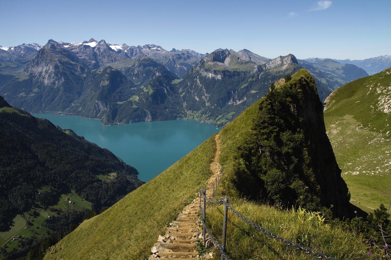
Renowned as one of Switzerland's finest high trails: the ridge path linking the Klingenstock and Fronalpstock peaks, with its many flights of steps. It affords views of more than ten Swiss lakes and countless Alpine peaks in Central Switzerland. You can also discover a variety of Alpine flowers along the route.

..Stoos+(Fronalpstock)&freizeit=1&noweather=1&width=400&height=200&x_axis_display=distance&polyline=axji%40yjhKmwB%3FfA%7B%40FaBn%40cA%3FsAvAAHwAbAr%40%3FyA%7EA%5CLeBz%40p%40FoAlAd%40JyA%7CAr%40HmBrADFuAhAPNkAtAQFyAxAe%40AaBdAw%40GyAhAm%40IwAlAO%3FoAvA%5EZ%7DA%7EA%60%40%60%40eBbAZJiA%7EAb%40BeBfBGJmBbAW%3FgAhA%3FQkAhBS%40kBh%40KNoAlAc%40h%40%7DAfAUVmAtAUP%7BArAJKwAtAA%40%7BAhAs%40H%7DAnAIYqA%7C%40k%40C%7DAxAUW%7BA%60Aq%40OuAjAy%40YaB%7E%40y%40%3FwAdBiAH%7DBf%40_%40%40s%40zAs%40HiB%7C%40y%40VuA%7E%40o%40HqA%7E%40%7B%40MwA%7C%40mA%3FcBr%40eA%3FwAr%40%7D%40MoAr%40_ABuAnAm%40%3FcB%60AAWmAnAf%40%5B%7BApAb%40%3FyA%7E%40CNwA%7E%40JZ%7BAvAIJyAp%40y%40CeB%5E_A%40kAXoAFcBlASHqAvAIDyAzAIO%7DApARK%7BApAWPuAnAV%5EwAnAh%40RyA%7CAXPaB%5DVVsA%60AMNyAXk%40TwARKTyAf%40KRoBJcAHcA%7E%40w%40F%7BAjAq%40Q%7DA%7E%40KYsA%60%40SWcBTg%40%5BsAd%40%60%40UaBn%40d%40_%40mAlAZWyAz%40AQwA%60%40_%40Q_BNkB_%40yBd%40RKy%40XqAWcB%60A_%40OuA%5EcAKmAtAe%40E_BbAeAOsBp%40i%40IaAb%40mA%40yAn%40sAFeBIy%40%40kAt%40w%40AuAc%40sAO%7DAs%40%7D%40GwADyAOyATsAGwA%3FiBBiBBwALyAf%40yA%40cBHw%40B%7B%40)