The first fixed rope route in Graubünden was created in 2005 at the back of the valley of St. Antönien at the southern wall of the Sulzfluh. The alpine route offers a lot of contact with rock and requires one to be quite fit.
Difficulty
level K4-5. A demanding and rather long route. Several steep stretches that drain one of energy; there are crossings at lofty heights. Not suitable for beginners.
Spot in the valley / Starting point
St. Antönien in Prättigau (1,420 meters). Bus from Küblis railway station to Rüti or parking lots below Partnun (1620 meters).
Ascent
A relatively long walk on the street follows the arrival by PostBus. Above the houses at Partnun there is a bridge over the eponymous brook, with a blue signpost that shows the way to the fixed rope route. From there a path that gets continually steeper and stonier leads to the starting point.
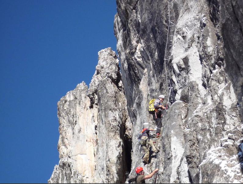
Sulzfluh Fixed Rope Route
In the lower portion the rock has steps with several short steep stretches. Nearly at the start of the route there is a ladder for overcoming the “entry wall”. One continues onwards to the “Obelix Crossing Point” and up to the ramp. From here onwards there is no opportunity to turn back! One subsequently encounters the “Goat’s Back” and the “Bench”. After one crosses the grassland the “Panoramica” begins, the second and steeper part of the impressive crossings in nearly vertical ledges and a balancing act on the “Deichmann Bridge”. The subsequent “Wailing Wall” is the last stretch and the most strenuous part of the route. Magnificent views await one at the peak crossing.
Descent
After descending on a sign-posted normal path, one traverses the Gemschtobel (secured with chains), which has white-red-white signposts. Subsequently one descends further down to Partnun.
Region: Rätikon, St. Antönien
Peak: Sulzfluh (2817m)
Duration of hike and climb: ascent 2 hours 15 minutes, fixed rope route 2 hours 30 minutes, descent 2 hours 15 minutes
Distance covered: 450 meters (fixed rope route), 1400 m (ascent and descent)