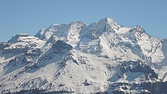
Its main peaks are:
- Blüemlisalphorn (3,660 m)
- Wyssi Frau (3,648 m) 46°29′35″N 7°47′0″E
- Morgenhorn (3,620 m) 46°29′46″N 7°47′28″E
- Oeschinenhorn
") (3,486 m)
(3,486 m)
The entire massif is contained within the
Canton of Bern , as it lies north of the main crest and water divide of the Bernese Alps. To the west, it is connected with the
Doldenhorn group via the
Fründenhorn ; to the east, it is continued by the
Gspaltenhorn . To the south, it is connected to the main crest by the
Tschingel Pass .
Ascent is from the Blüemlisalphütte (2,840 m), over the glacier, past the Wildi Frau (3,274 m)
Geography
The Blüemlisalp forms a ridge of great height, cut away in precipices on the southeast side, surmounted by four principal peaks, in the following order, reckoning from east to west: Morgenhorn (3,620 m), Wyssi Frau (3,648 m), the Blüemlisalphorn (3,660 m) and the Oeschinenhorn (3,486 m). To the southwest of the last peak, and between it and the Doldenhorn, is a minor summit — the Fründenhorn (3,368 m).

 Determining current location...