DE
FR
IT
EN
Telefonbuch
Wetter
Karte / Route
Fahrplan
Freizeit
TV
Kino
Websuche
Apps
Mehr
Persönliche Informationen »
Anmelden:
Registrieren
Passwort vergessen
oder
Anmelden mit local.ch
Anmelden mit Apple
Anmelden mit Facebook
Anmelden mit Google
Anmelden mit LinkedIn
Bitte beachten Sie, dass unsere neue
Datenschutzerklärung
sowie die angepassten
Nutzungsbedingungen
gelten.
Freizeit
Wanderung in Val-de-Ruz
Jura-Höhenweg, Etappe 9/16
Nationale Route Nr. 5, Etappe 9: Vue des Alpes – Noiraigue
Beschreibung
Nationale Route
Nr. 5 (Dielsdorf – Nyon)
Länge
22 km
Aufstieg • Abstieg
↑ 860 m • ↓ 1400 m
Tiefster Punkt • Höchster Punkt
729 m • 1438 m
Wanderzeit
6 h 45 min
Technik
leicht
Kondition
schwer
Nationale Route Nr. 5:
Jura-Höhenweg
Etappen
1. Dielsdorf – Brugg
2. Brugg AG – Staffelegg
3. Staffelegg – Hauenstein
4. Hauenstein – Balsthal
5. Balsthal – Weissenstein
6. Weissenstein – Frinvillier
7. Frinvillier – Chasseral
8. Chasseral – Vue des Alpes
9. Vue des Alpes – Noiraigue
10. Noiraigue – Les Rochats
11. Les Rochats – Ste-Croix
12. Ste-Croix – Ballaigues
13. Ballaigues – Le Pont
14. Le Pont – Col du Marchairuz
15. Col du Marchairuz – St-Cergue
16. St-Cergue – Nyon
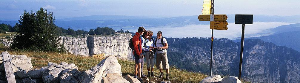
Auf der hohen Bergkette mit den Gipfeln Tête de Ran und Mont Racine kann ein herrliches Panorama genossen werden und die Felskanzel Tablettes erlaubt vor dem steilen Abstieg nach Noiraigue einen atemberaubenden Tiefblick auf den Lac de Neuchâtel.
Anmerkungen zu diesen Informationen?
Wir freuen uns über Ihr Feedback!
Präsentiert von
Route
Höhenprofil
Wetter:
Mehr...
Anmerkungen zu dieser Aktivität oder diesem Ort?
Falsche Angaben
Fehlende Informationen
Anderes Thema
Vielen Dank für dein Feedback!
Schliessen