DE
FR
IT
EN
Telefonbuch
Wetter
Karte / Route
Fahrplan
Freizeit
TV
Kino
Websuche
Apps
Mehr
Persönliche Informationen »
Anmelden:
Registrieren
Passwort vergessen
oder
Anmelden mit local.ch
Anmelden mit Apple
Anmelden mit Facebook
Anmelden mit Google
Anmelden mit LinkedIn
Bitte beachten Sie, dass unsere neue
Datenschutzerklärung
sowie die angepassten
Nutzungsbedingungen
gelten.
Freizeit
Wanderung in Saas-Fee
Swiss Tour Monte Rosa
Regionale Route Nr. 27, Saas Fee – Zermatt
Beschreibung
Regionale Route
Nr. 27 (Saas Fee – Zermatt)
Länge
56 km
Aufstieg • Abstieg
↑ 4000 m • ↓ 4200 m
Tiefster Punkt • Höchster Punkt
1310 m • 2386 m
Technik
mittel
Kondition
schwer
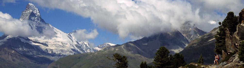
Regionale Route Nr. 27: Swiss Tour Monte Rosa
Etappen
1. Saas Fee – Grächen
2. Grächen – Europahütte
3. Europahütte – Zermatt
Starke Kombination: Der Balfrin-Höhenweg von Sass-Fee nach Grächen und der Europaweg von Grächen nach Zermatt bilden die «Swiss Tour Monte Rosa». Drei Tage Panoramawandern mit spektakulären Aussichten auf die eisigen 4000er des Saas- und Mattertals.
Anmerkungen zu diesen Informationen?
Wir freuen uns über Ihr Feedback!
Präsentiert von
Route
Höhenprofil
Wetter:
Mehr...
Anmerkungen zu dieser Aktivität oder diesem Ort?
Falsche Angaben
Fehlende Informationen
Anderes Thema
Vielen Dank für dein Feedback!
Schliessen